Nazca Lines Tour: How to See the Ancient Geoglyphs

The best way to see the Nazca Lines is a short scenic flight from Nazca itself, because the giant animal figures only make sense from above. A Nazca Lines tour usually pairs that 30-minute flight with a drive down Peru's southern coast, often stopping at Paracas and the Huacachina oasis. This guide explains what the lines are, how to view them, how to reach Nazca from Lima, and how to build the trip into a wider coastal route.
What Are the Nazca Lines?
The Nazca Lines are enormous geoglyphs carved into the desert floor of southern Peru, spread across an area of roughly 725 square km (NPR, 2022). Ancient people made them by scraping away the dark, iron-rich surface stones to reveal the pale ground beneath. The dry, windless climate has kept them visible for around 2,000 years.
The designs fall into two broad groups. Some are simple straight lines and geometric shapes, spanning kilometers across the plain. Others are figures: a hummingbird, a monkey, a spider, a condor, and dozens more plants and animals. Most were created by the Nasca culture between roughly 100 BCE and 300 CE.
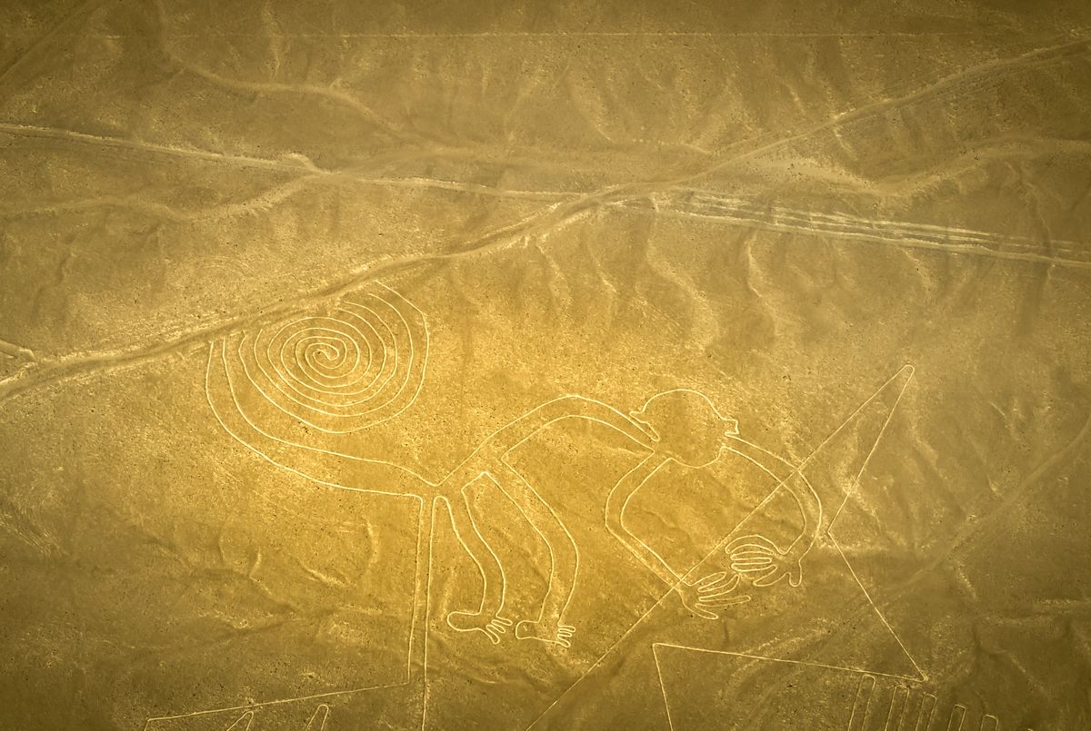
The site has been protected as a UNESCO World Heritage listing since 1994, which you can read about on the official UNESCO World Heritage Centre record. That status covers the core plateau and the surrounding archaeological zone.
Why Did They Make the Lines?
No single theory has won the argument. The most famous explanation came from Maria Reiche, a German mathematician who spent decades mapping the figures. She argued the lines formed a giant astronomical and agricultural calendar, marking solstices and the movement of stars.
Other researchers connect the geoglyphs to water. In a desert this harsh, many scholars think the lines served ritual purposes tied to rain, fertility, and mountain deities, with some acting as ceremonial walking paths toward the sacred center of Cahuachi. The truth may combine several of these ideas.
Discoveries keep coming. In a 2024 study, a research team using artificial intelligence identified 303 previously unknown figurative geoglyphs, nearly doubling the known count in one effort (Live Science, 2024). The total number of recorded geoglyphs now runs well past 800.
Nazca Lines Tour: Flights vs Viewing Towers
A scenic flight is the only way to see the full animal figures, since most are far too large to read from ground level. A roadside viewing tower offers a cheaper, quicker alternative, but it reveals just two or three geoglyphs and only in part. Your choice depends on budget, time, and how much the figures matter to you.
The flights leave from Maria Reiche Neuman Airport, on the edge of Nazca town. A typical route traces the best-known figures one after another. Because the plane has to bank steeply so passengers on both sides can see, the ride can feel bumpy, and motion sickness is common. Fly early, when the air is calmest and the light rakes across the lines.
The alternative is the mirador, a metal viewing tower beside the Pan-American Highway north of town. From the top you can make out the hands and tree figures. It costs very little and takes minutes, but it is a glimpse rather than the full picture.
Our finding: On balance, travelers who skip the flight to save money almost always regret it. The figures are the whole point of the visit, and the tower simply cannot show the hummingbird or monkey in full.
For a sense of how Peru's weather shifts through the year, our guide to the best time to visit Peru covers the southern coast, where clear desert skies make the flights more dependable than in the highlands.
How Do You Get to Nazca From Lima?
Nazca sits about 445 km south of Lima along the Pan-American Highway, a drive of roughly six hours. There is no passenger airport in Nazca for arrivals, so nearly everyone comes overland by bus, private transfer, or guided tour vehicle.
Long-distance buses are the standard option. Comfortable services run day and night, taking seven to nine hours depending on stops, often pausing in Ica or Paracas. Many travelers break the journey rather than doing it in one push, which also opens up the coastal sights along the way.
Here is how the main routes compare.
| Option | Typical time | Best for |
|---|---|---|
| Private transfer or tour vehicle | About 6 hours | Comfort, flexible stops |
| Long-distance bus | 7 to 9 hours | Budget, overnight travel |
| Self-drive | About 6 hours | Independent coastal road trips |
If you are already mapping a longer Peru itinerary, a flight to Nazca does not replace the famous highland sites. Many visitors still prioritize Cusco and Machu Picchu, then add the southern coast as a separate leg before or after the mountains.
What to Expect on a Scenic Flight
A Nazca scenic flight lasts around 30 to 35 minutes in a small propeller aircraft seating roughly six passengers. The pilot calls out each figure by name and circles twice, tilting the wings so travelers on the left and right both get a clear look. Expect tight turns and real desert heat on the tarmac.
Arrive early for a weigh-in; small planes balance passengers by weight. Bring sunglasses, keep the camera strap around your neck, and skip a heavy breakfast if you are prone to queasiness. Ginger tablets help. The constant banking is what unsettles stomachs, not the altitude.
Weather matters. Morning flights usually offer steadier air and sharper shadows that make the figures pop. Afternoon winds can delay or cancel departures, so build a buffer day if your schedule is tight. A guided package often handles the booking, airport fees, and timing for you, which is where an operator like Peru Trippers can smooth out a trip that depends on narrow weather windows.
Combining Nazca With Paracas and Huacachina
Nazca works beautifully as part of a southern coast loop with Paracas and Huacachina, since all three lie within a few hours of each other along the Pan-American Highway. A common plan runs three to four days out of Lima, giving you marine wildlife, a desert oasis, and the geoglyphs in one trip.
Paracas comes first for most travelers. Its national reserve protects sea lions, penguins, and flamingos, and boat trips visit the Ballestas Islands offshore. The candelabra geoglyph etched into a coastal hillside makes a neat preview of what waits inland at Nazca.
Huacachina sits next, a palm-fringed lagoon surrounded by towering dunes just outside Ica. Dune buggies and sandboarding fill an afternoon, and sunset over the sand is the signature image of Peru's coast. From Ica it is a short hop south to Nazca for the flight.
Want a longer route? After the coast, many travelers fly from Lima to the south and continue to Arequipa, where our Colca Canyon tour guide picks up the thread with condors and deep gorges.
Planning Your Visit
Book your Nazca flight for the morning, protect one spare day for weather, and treat Paracas and Huacachina as the natural companions on the drive down. A loose plan beats a rigid one here, because the desert sets its own schedule. If you would rather hand the logistics to someone who runs the coast regularly, compare guided southern-coast packages and lock in your flight slot before you travel, when the best morning departures fill up fastest.
Frequently asked questions
Do you need to fly to see the Nazca Lines?
A flight is the only way to see the full animal figures such as the hummingbird and monkey. A roadside viewing tower shows two or three geoglyphs from the ground, but most of the designs are too large to read at eye level.
How long is a Nazca Lines scenic flight?
Most flights last 30 to 35 minutes in a small propeller plane carrying around six passengers. The pilot banks over each major figure twice, once for each side of the aircraft, so everyone gets a clear view.
How do you get to Nazca from Lima?
Nazca lies roughly 445 km south of Lima along the Pan-American Highway, about a six-hour drive. Comfortable long-distance buses run the route in seven to nine hours, usually stopping in Ica or Paracas on the way.
Can you combine Nazca with Paracas and Huacachina?
Yes. All three sit along the southern coast within a few hours of each other. A common three to four day loop from Lima covers the Paracas marine reserve, the Huacachina desert oasis, and a Nazca flight.
Are the Nazca Lines worth seeing?
For travelers interested in archaeology and desert landscapes, yes. The geoglyphs cover an area of around 725 square km and remain one of the great unsolved puzzles of the ancient Americas, best appreciated from the air.